


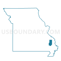
Scopus Voting District, Bollinger County, Missouri
About
Outline

Summary
| Unique Area Identifier | 607120 |
| Name | Scopus Voting District |
| County | Bollinger County |
| State | Missouri |
| Area (square miles) | 38.64 |
| Land Area (square miles) | 38.58 |
| Water Area (square miles) | 0.06 |
| % of Land Area | 99.84 |
| % of Water Area | 0.16 |
| Latitude of the Internal Point | 37.41256370 |
| Longtitude of the Internal Point | -89.92825240 |
Maps


Graphs
Select a template below for downloading or customizing gragh for Scopus Voting District, Bollinger County, Missouri


Neighbors
Neighoring Voting District (by Name) Neighboring Voting District on the Map
- Bollinger Voting District, Bollinger County, MO
- Burfordville Voting District, Cape Girardeau County, MO
- Hurricane Voting District, Bollinger County, MO
- Marble Hill No. 1 Voting District, Bollinger County, MO
- Millersville Voting District, Cape Girardeau County, MO
- Younts Store Voting District, Bollinger County, MO
Top 10 Neighboring County Subdivision (by Population) Neighboring County Subdivision on the Map
- Lorance township, Bollinger County, MO (4,366)
- Scopus township, Bollinger County, MO (1,518)
- Whitewater township, Cape Girardeau County, MO (1,335)
- Crooked Creek township, Bollinger County, MO (1,234)
- Kinder township, Cape Girardeau County, MO (1,158)
Top 10 Neighboring Unified School District (by Population) Neighboring Unified School District on the Map
- Jackson R-II School District, MO (30,067)
- Woodland R-IV School District, MO (5,940)
- Meadow Heights R-II School District, MO (3,747)
Top 10 Neighboring State Legislative District Lower Chamber (by Population) Neighboring State Legislative District Lower Chamber on the Map
- State House District 157, MO (37,900)
- State House District 159, MO (35,685)
- State House District 156, MO (34,716)
Top 10 Neighboring State Legislative District Upper Chamber (by Population) Neighboring State Legislative District Upper Chamber on the Map
Top 10 Neighboring 111th Congressional District (by Population) Neighboring 111th Congressional District on the Map
Top 10 Neighboring Census Tract (by Population) Neighboring Census Tract on the Map
- Census Tract 9501, Bollinger County, MO (4,691)
- Census Tract 9502, Bollinger County, MO (4,609)
- Census Tract 8803, Cape Girardeau County, MO (4,387)
- Census Tract 8802, Cape Girardeau County, MO (3,822)